301 - 332 of 332
![Lot image - [PARIS] [VARIOUS AUTHORS AND ILLUSTRATORS]. Paris Guide par les Principaux Écrivains et Artistes de la France.](/sites/default/files/images/lots/608/1624608.jpg)
Lot 300
[PARIS] [VARIOUS AUTHORS AND ILLUSTRATORS]. Paris Guide par les Principaux Écrivains et Artistes de la France.
Estimate: $60 - $80
Sold for $126
(includes buyer's premium)
![Lot image - [PHOTOGRAPHY - TRAVEL] The archive of a professional travel photographer, circa](/sites/default/files/images/lots/699/1573699.jpg)
Lot 301
[PHOTOGRAPHY - TRAVEL] The archive of a professional travel photographer, circa
Estimate: $2,500 - $5,000
Unsold
![Lot image - [RMS TITANIC] Model of the Titanic, approximately 1/350 scale, with a plaque signed by the last living survivor Millvina Dean, and a small piece of coal recovered during the 1994 Titanic Research and Recovery Expedition.](/sites/default/files/images/lots/236/1621236.jpg)
Lot 302
[RMS TITANIC] Model of the Titanic, approximately 1/350 scale, with a plaque signed by the last living survivor Millvina Dean, and a small piece of coal recovered during the 1994 Titanic Research and Recovery Expedition.
Estimate: $400 - $600
Sold for $535
(includes buyer's premium)
![Lot image - [AUCTION MAP - GREENWICH VILLAGE] BLEECKER & SONS, JAMES. Map of Real Estate to be Leased at Auction on Wednesday, March 27th... at the Merch[an]ts Exchange. A Range of Elegant 3 Story new brick Houses built by I. G. Pearson & Others.](/sites/default/files/images/lots/375/1633375.jpg)
![Lot image - [AUCTION MAP - GREENWICH VILLAGE] BLEEKER & SON, JAMES. Map of Property in the Fifteenth Ward of New York to be Sold by Public Auction at the Merchants Exchange.](/sites/default/files/images/lots/147/1633147.jpg)
![Lot image - [MAP - NEW YORK CITY PROPERTY AUCTION] JAMES BLEEKER & SONS. Map of Property in the 4th, 6th & 7th Wards of the City of New Yor...](/sites/default/files/images/lots/314/1617314.jpg)
Lot 305
[AUCTION MAP - NEW YORK CITY] JAMES BLEECKER & SONS. Map of Property in the 4th, 6th & 7th Wards of the City of New York belonging to the Est.e of Garrit B. Abeel, dec.d. To be sold at Auction by James Bleeker & Sons on Saturday 9th of March 1833. By order of the Court of Chancery & under the direction of Frederic De Peyster Jr. Esqr.
Estimate: $600 - $900
Sold for $378
(includes buyer's premium)
![Lot image - [AUCTION MAPS- NEW YORK CITY] BLEECKER, ANTHONY. Three nineteenth century real estate auction maps of property sold by Anthony J. Bleecker.](/sites/default/files/images/lots/860/1632860.jpg)
Lot 306
[AUCTION MAPS- NEW YORK CITY] BLEECKER, ANTHONY. Three nineteenth century real estate auction maps of property sold by Anthony J. Bleecker.
Estimate: $400 - $600
Sold for $252
(includes buyer's premium)
![Lot image - [AUCTION MAPS- NEW YORK CITY] ROLLINS, GEORGE B. Two nineteenth century real estate auction maps of waterfront adjacent properties, sold by George B. Rollins,](/sites/default/files/images/lots/936/1632936.jpg)
Lot 307
[AUCTION MAPS- NEW YORK CITY] ROLLINS, GEORGE B. Two nineteenth century real estate auction maps of waterfront adjacent properties, sold by George B. Rollins,
Estimate: $300 - $500
Sold for $189
(includes buyer's premium)
![Lot image - [BOWERY LANE] BANCKER Jr., EVERT and TAYLOR, B. An original late 18th century survey map of Bowery Lane.](/sites/default/files/images/lots/340/1627340.jpg)
Lot 308
[BOWERY LANE] BANCKER Jr., EVERT and TAYLOR, B. An original late 18th century survey map of Bowery Lane.
Estimate: $300 - $500
Sold for $252
(includes buyer's premium)
![Lot image - [MAPS - BOWERY] Three maps of Bowery Area,](/sites/default/files/images/lots/642/1580642.jpg)
Lot 309
[MAPS - BOWERY] Three maps of Bowery Area,
Estimate: $1,000 - $1,500
Sold for $630
(includes buyer's premium)
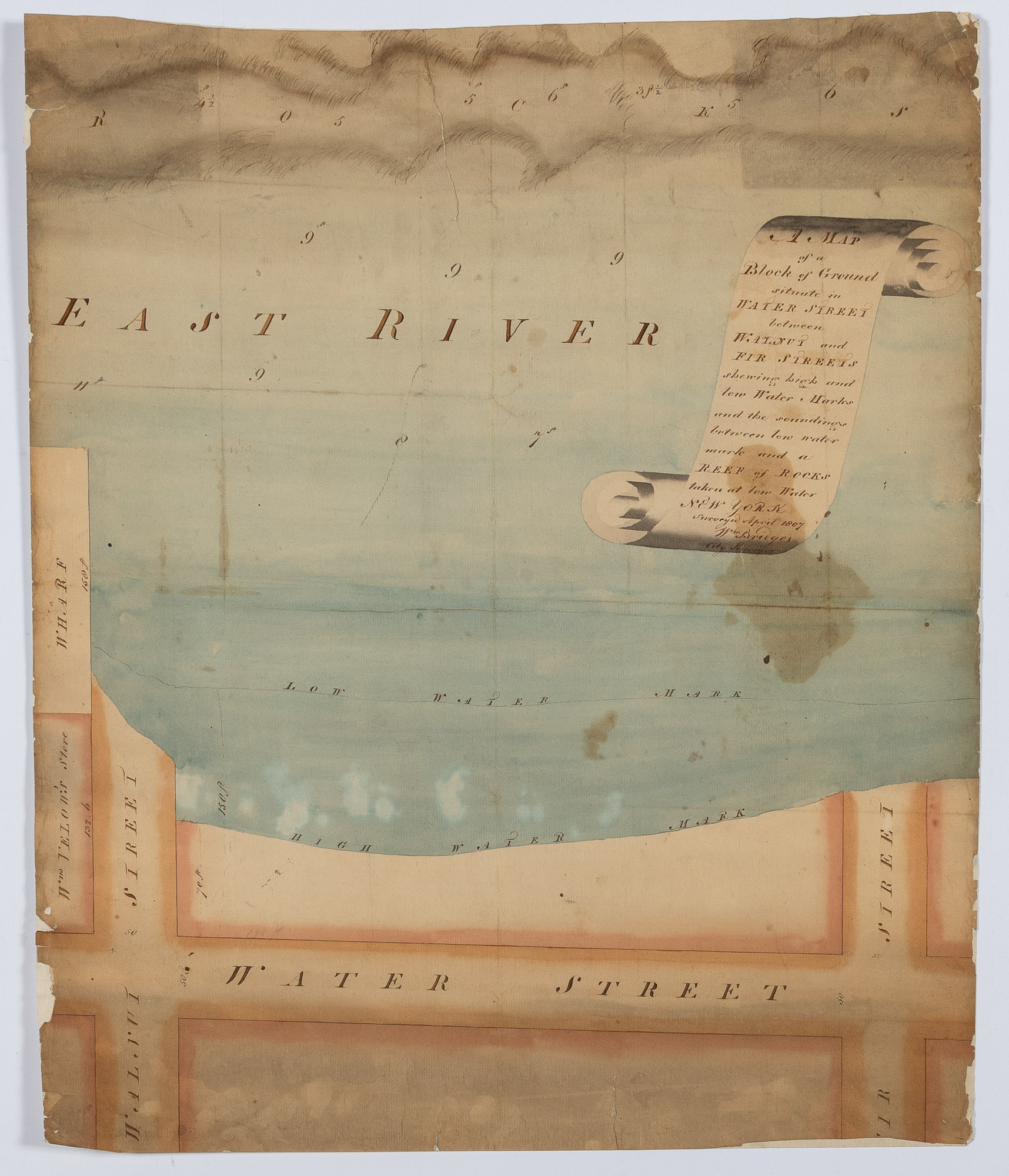
Lot 310
BRIDGES, WILLIAM A Map of a Block of Ground situate in Water Street between Walnut and Fir Streets showing high and low Water Marks and the soundings between low water mark and a Reef of Rocks taken at low Water.
Estimate: $1,500 - $2,500
Sold for $1,008
(includes buyer's premium)
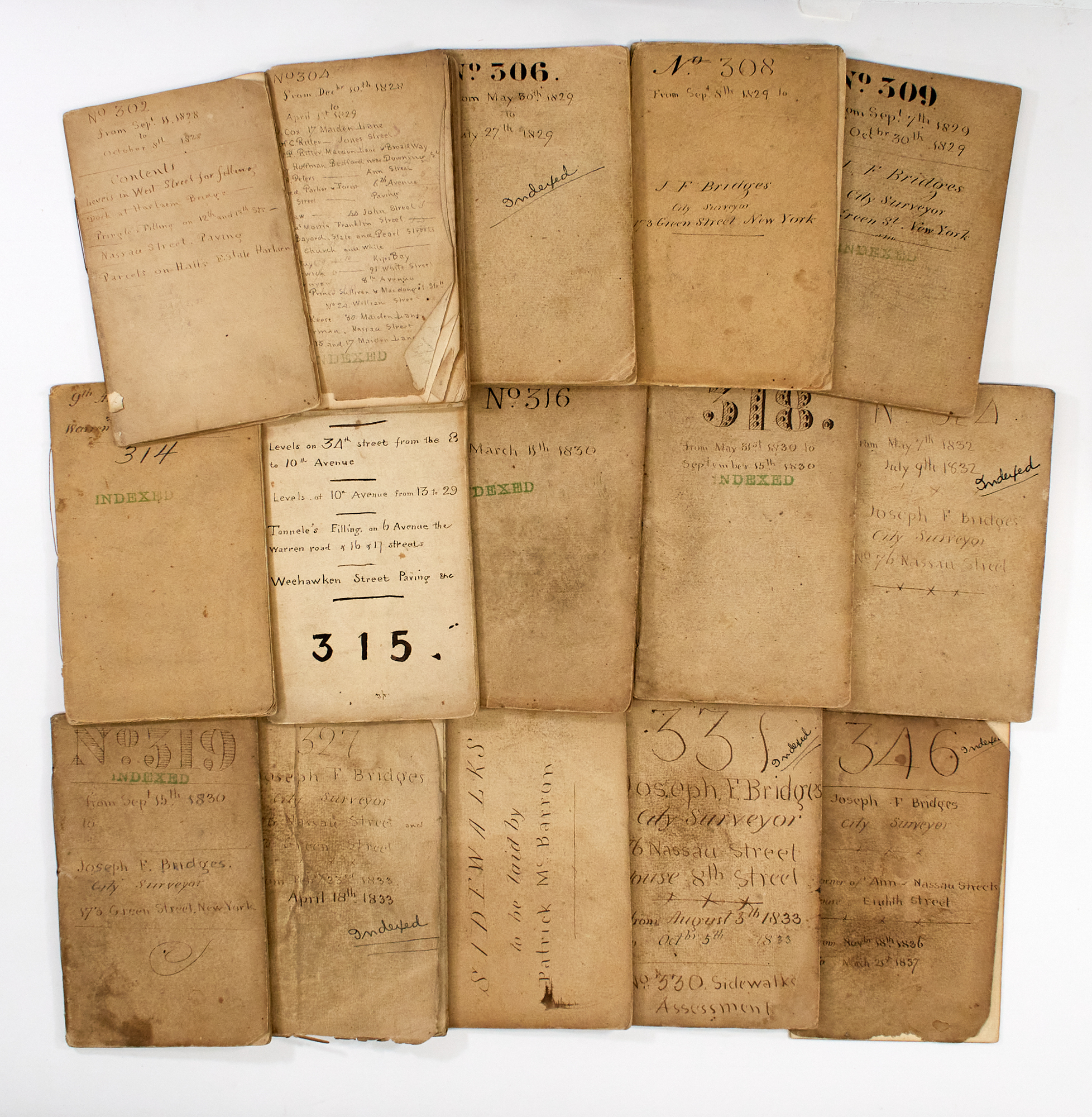
Lot 311
BRIDGES, JOSEPH F. Collection of fourteen manuscript field notebooks.
Estimate: $2,000 - $3,000
Sold for $1,638
(includes buyer's premium)
![Lot image - [MAP - CHELSEA] HOLMES, J[OHN] B[UTE]. Map of Property formerly a part of the 12th Ward of the City of New York belonging to the Estate of James A. Stewart deceased, Accurately made from Deeds recorded in the Registers Office....](/sites/default/files/images/lots/360/1627360.jpg)
![Lot image - [MAP - EAST RIVER SHORELINE] SMITH, EDWIN. Map of the East River Shore from 13th to the 28th Streets, Shewing East Street from...](/sites/default/files/images/lots/643/1580643.jpg)
Lot 313
[MAP - EAST RIVER SHORELINE] SMITH, EDWIN. Map of the East River Shore from 13th to the 28th Streets, Shewing East Street from 13th to the 28th Streets, as per Ordinance of Common Council Dec.r 31st 1856 and also the Harbour Commissioner's Pier Head Line, from 13th to 17th Streets, & Sea Wall Line from 17th to 23rd Street.
Estimate: $600 - $900
Unsold
![Lot image - [MAP - FINANCIAL DISTRICT] SMITH, GEO[RGE] B.; after BRIDGES and POPPLETON. Map of Property on Dey and Washington Streets of the East of Bonsall...](/sites/default/files/images/lots/229/1625229.jpg)
Lot 314
[MAP - FINANCIAL DISTRICT] SMITH, GEO[RGE] B.; after BRIDGES and POPPLETON. Map of Property on Dey and Washington Streets of the East of Bonsall...
Estimate: $600 - $900
Sold for $378
(includes buyer's premium)
![Lot image - [GREAT JONES STREET] GOERCK, CASIMIR THEODOR. Map of Several Lots of Ground being part of the Property of Doctor Gardiner Jones.](/sites/default/files/images/lots/336/1627336.jpg)
Lot 315
[GREAT JONES STREET] GOERCK, CASIMIR THEODOR. Map of Several Lots of Ground being part of the Property of Doctor Gardiner Jones.
Estimate: $300 - $500
Sold for $189
(includes buyer's premium)
![Lot image - [GOERCK, CASIMIR THEODOR, after] A Map of Mr. Effn Embree & Others place formerly belonging to Anthony Rutgers laying westerly of Great George Street. Surveyed Sept. 6th 1790 by Casimir Th. Goerck, City Surveyor.](/sites/default/files/images/lots/308/1603308.jpg)
Lot 316
[GOERCK, CASIMIR THEODOR, after] A Map of Mr. Effn Embree & Others place formerly belonging to Anthony Rutgers laying westerly of Great George Street. Surveyed Sept. 6th 1790 by Casimir Th. Goerck, City Surveyor.
Estimate: $800 - $1,200
Sold for $504
(includes buyer's premium)
![Lot image - [MAP - GREENWICH VILLAGE] EWEN, D[ANIEL]; and THOS. R. LUDLOW. Map No. 1 of a piece of Land situated at Greenwich in the Ninth Ward of the City of New York shewing a division of the same between the Heirs of John Rogers Dec[ease]d.](/sites/default/files/images/lots/324/1627324.jpg)
![Lot image - [MAP - GREENWICH VILLAGE] EWEN, DAN[IE]L; and THO[MA]S R. LUDLAM; with E[DWIN] S[MITH]. Map No. 2 of a Piece of Land Situated i...](/sites/default/files/images/lots/227/1625227.jpg)
![Lot image - [MAP - GREENWICH VILLAGE] SMITH, E[DWIN]; after W. B. DOUGHTY. Map of Property in the Ninth Ward of the City of New York Belonging to William Thomas.](/sites/default/files/images/lots/325/1627325.jpg)
Lot 319
[MAP - GREENWICH VILLAGE] SMITH, E[DWIN]; after W. B. DOUGHTY. Map of Property in the Ninth Ward of the City of New York Belonging to William Thomas.
Estimate: $300 - $500
Sold for $189
(includes buyer's premium)
![Lot image - [MAP - GREENWICH VILLAGE] SMITH, W[ILLIA]M A. [?]. Map of Property Belonging to the Orphan Asylum Society in the 9th Ward of the City of New York](/sites/default/files/images/lots/326/1627326.jpg)
Lot 320
[MAP - GREENWICH VILLAGE] SMITH, W[ILLIA]M A. [?]. Map of Property Belonging to the Orphan Asylum Society in the 9th Ward of the City of New York
Estimate: $400 - $600
Unsold
![Lot image - [MAP - GREENWICH VILLAGE] SMITH, GEO[RGE] B.; [after] EDWIN SMITH. [A manuscript survey map showing the Hudson River waterfront in Greenwich Village, including Fort Ganseveoort.](/sites/default/files/images/lots/327/1627327.jpg)
Lot 321
[MAP - GREENWICH VILLAGE] SMITH, GEO[RGE] B.; [after] EDWIN SMITH. [A manuscript survey map showing the Hudson River waterfront in Greenwich Village, including Fort Ganseveoort.
Estimate: $600 - $900
Sold for $504
(includes buyer's premium)
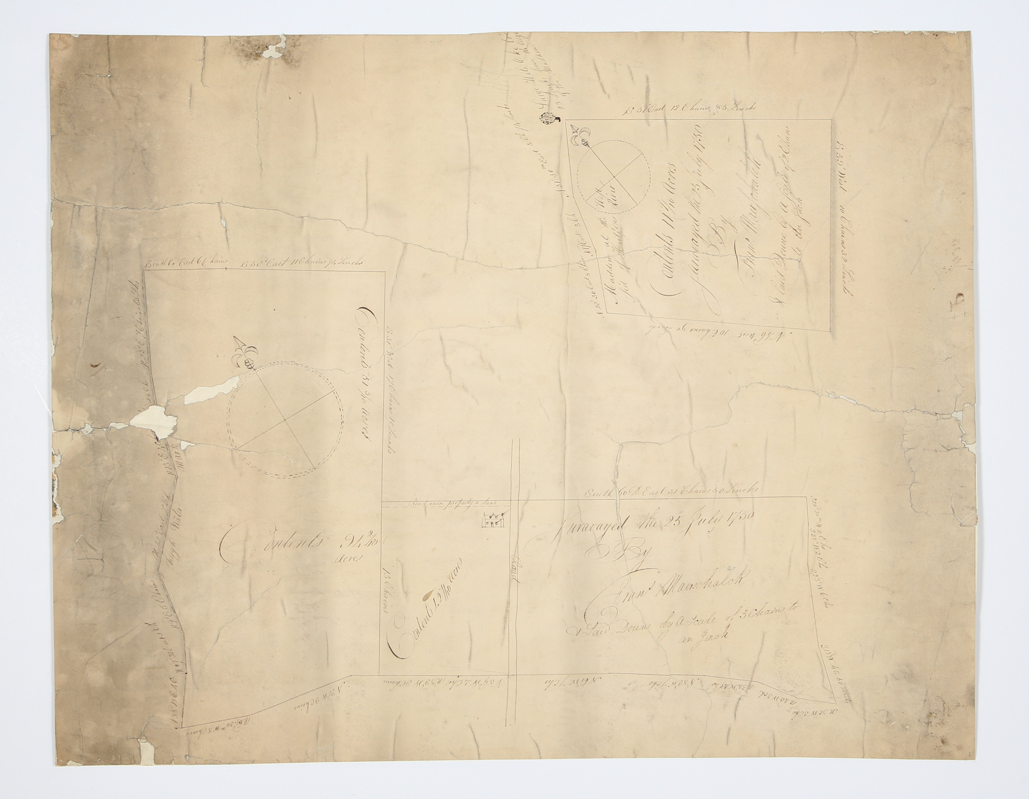
![Lot image - [MURRAY HILL] MAERSCHALK, FRANCIS M. Mansucript map on vellum of the Blomendal (Bloomingdale) Road near Inclenburg, 1763.](/sites/default/files/images/lots/317/1627317.jpg)
Lot 323
[MURRAY HILL] MAERSCHALK, FRANCIS M. Mansucript map on vellum of the Blomendal (Bloomingdale) Road near Inclenburg, 1763.
Estimate: $2,000 - $3,000
Unsold
![Lot image - [MAP - MURRAY HILL and MIDTOWN EAST] HOLMES, J[OHN] B [UTE]. Map of the Murray Hill Farm, Ogden Place Farm, Lawrence & Astor, Wiswall & Price, Corporation, Wm. Wright, John Taylor and Other Property.](/sites/default/files/images/lots/361/1627361.jpg)
Lot 324
[MAP - MURRAY HILL and MIDTOWN EAST] HOLMES, J[OHN] B [UTE]. Map of the "Murray Hill Farm," "Ogden Place Farm," Lawrence & Astor, Wiswall & Price, Corporation, Wm. Wright, John Taylor and Other Property.
Estimate: $600 - $900
Sold for $1,386
(includes buyer's premium)
![Lot image - [MAP - NEWGATE PRISON] SMITH, GEO[RGE] B.; after A[BEL] CORNING. [Survey Map of Newgate State Prison in the West Village].](/sites/default/files/images/lots/322/1627322.jpg)
Lot 325
[MAP - NEWGATE PRISON] SMITH, GEO[RGE] B.; after A[BEL] CORNING. [Survey Map of Newgate State Prison in the West Village].
Estimate: $800 - $1,200
Unsold
![Lot image - [MAPS - NOHO] Three nineteenth century manuscript survey maps showing Great Jones Street between Broadway and Bowery, as well as parts of Bond and Bleeker streets](/sites/default/files/images/lots/627/1580627.jpg)
Lot 326
[MAPS - NOHO] Three nineteenth century manuscript survey maps showing Great Jones Street between Broadway and Bowery, as well as parts of Bond and Bleeker streets
Estimate: $800 - $1,200
Sold for $504
(includes buyer's premium)
![Lot image - [MAPS - NOHO] Two early nineteenth century manuscript survey maps of Bleeker Street and Bond Street between Broadway and Bowery.](/sites/default/files/images/lots/384/1629384.jpg)
Lot 327
[MAPS - NOHO] Two early nineteenth century manuscript survey maps of Bleeker Street and Bond Street between Broadway and Bowery.
Estimate: $600 - $900
Sold for $630
(includes buyer's premium)
![Lot image - [MAP - UNION SQUARE] Map of the lots leased by C.T. Williams to Samuel B. Ruggles Esq.](/sites/default/files/images/lots/366/1627366.jpg)
Lot 328
[MAP - UNION SQUARE] Map of the lots leased by C.T. Williams to Samuel B. Ruggles Esq.
Estimate: $600 - $900
Sold for $378
(includes buyer's premium)
![Lot image - [MAP - UPPER EAST SIDE] HOLMES, JOHN BUTE. Map of the Common Lands from 76th to 93rd Street showing the old streets & plots as...](/sites/default/files/images/lots/363/1627363.jpg)
Lot 329
[MAP - UPPER EAST SIDE] HOLMES, JOHN BUTE. Map of the Common Lands from 76th to 93rd Street showing the old streets & plots as Surveyed and Mapped in 1796 by Cassimer T. H. Goerck, City Surveyor and resurveyed by Isaac T. Ludlam in 1822, and the distance between those old streets and our present streets.
Estimate: $200 - $400
Sold for $126
(includes buyer's premium)
![Lot image - [MAP - UPPER MANHATTAN] EWEN, EDWARD S and HAMILTON EWEN. Map of the City of New York North of 155th St. Showing the progress m...](/sites/default/files/images/lots/659/1580659.jpg)
Lot 330
[MAP - UPPER MANHATTAN] EWEN, EDWARD S and HAMILTON EWEN. Map of the City of New York North of 155th St. Showing the progress made in laying out Streets, Avenues, Roads, Public Squares and Places by the Commissioners of Central Park, Under Chap. 565 of Laws of 1865 and of New Pier and Bulkhead Lines under Chap. 695 of Laws of 1867.
Estimate: $800 - $1,200
Sold for $1,008
(includes buyer's premium)
![Lot image - [MAP - UPPER MANHATTAN] HOLMES, J. B. and CHARLES J. HUNT. Map of Property in Harlem Formerly Belonging to the Bowers, Moore, S...](/sites/default/files/images/lots/364/1627364.jpg)